
The NBV’s Steve Keenan describes the top ten shorter walks in the Vale.
The original piece included details of cafes and pubs en route, but sadly you will have to take a Thermos now. And ensure walks are only a short drive from your home…
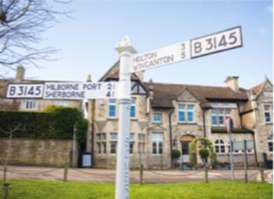
The Blackmore Vale is blessed with a number of Big Walks including the North Dorset Trailway, Stour Valley Way, The White Hart Link and Wessex Ridgeway. Which we very grateful for. But in January, the weather is more conducive to a shorter walk. Two or three miles maybe, and back to a warm place within an hour.
Last year certainly saw us getting outside more, walking the dog more and being grateful for living in such a gloriously rural part of the world. ViewRanger is an app and website that hosts hundreds of walking routes posted by individuals, and a spokesman said that activity on its sites shot up spectacularly in the spring.
“We looked at 300 of our most popular walking routes over the spring and summer 2020, then compared to a similar period before spring. We found a stunning 151% increase in activity overall. This is partly explained by seasonal factors but it also shows that taking our exercise in the fresh air, socially distanced, formed a vital part of our physical and mental wellbeing.”
So we asked ViewRanger to dig out which were the 10 most popular short walks in our area in 2020, by order of popularity – and here they are. More details and maps of the 10 walks at: my.viewranger.com/route/curations/1349
Chard reservoir, Somerset: Length, 2.44 miles. Surface, smooth. Difficulty, easy. A lovely walk around the reservoir, mostly on paved paths including the old Taunton to Chard railway line, so it’s great for winter walks. Look out for the bird hide and the ruined boathouse.
Horton Tower, Dorset: Length, 2.29 miles. Surface, moderate. Difficulty, medium. Park in Drusilla’s Inn, a closed pub now up for sale. The first and last parts of the walk are on the road, the rest across fields to the five- storey Gothic red brick tower. Glorious views.
Oborne, Dorset: Length, 2.03 miles. Surface, moderate. Difficulty, medium. Between Sherborne and Milborne Port, this circular walk takes you along Vartenham Hill escarpment. You can park near the railway bridge, at the end of Donkey Lane, or in Milborne Port.
Gold Hill, Shaftesbury: Length, 2.9 miles. Surface, moderate. Difficulty, medium. A walk that takes you through the town with views over the Vale, down Pine Walk to St James and French Mill Lane before climbing up the hill.
Stourpaine to Hod Hill, Dorset: Length, 2.03 miles. Surface, moderate. Difficulty, medium. Park at The White Horse pub on the A350 then take a 400ft ascent to the old Roman Fort before heading back to the pub.
Charlton Horethorne Length: 2.2 miles (3.5km) Total ascent: 197ft. This is an easy walk up a metalled track, around a field and back down through a coombe called The Cleeve, an undulating valley leading to the village pub.
Take the road opposite St Peter and St Paul’s church. This is Cowpath Road, a clue as to where it leads. Just past Primrose Lodge on the left is a small car park next to the football pitch.
Head past Centenary Cottages and up the gently rising track. The high sided hedges prevent views but pass by two sentinel trees either side the track and gaps and gates in the hedge begin to afford a better outlook. At its high point, the walk is 175m above sea level and the views are huge, to the Wessex Ridgeway in the south and Alfred’s Tower 12 miles away to the north.
The village lies below your feet to the east but the slope up to the west prevents a view bar an expanse of sky. An S-bend in the track reveals two five-bar gates ahead and it’s at this point that you are most exposed to wind – a westerly on the day I walked it and I was glad of a hat. The gate to the left leads up to farm buildings. Take the other gate and walk the perimeter of the field keeping the hedge to your left in a dog leg shape.
After a leisurely right, left, right, you’ll see the coombe down below. You can descend from here and follow it around to the right. It’s a lovely walk back down the valley to the village through sheep and cattle pastures.
There are two rickety stiles to contend with and on my winter walk, the mud at the second was knee deep. Another walker sensibly suggested walking up the slope to the left and climbing over a gate: small dogs can slither under the barbed wire. You can peel off to the right towards the first house you see which will take you back to Cowpath Road and your car. Or, when it is alowed to reopen, you can carry on down the coombe to the village and The Kings Arms, a very traditional country inn on the green, where in normal times you can enjoy a warming meal and a pint.
Support Us
Thank you all so, so much for the love and appreciation you’ve shown us since we launched the New Blackmore Vale.
Please show your support and add a review on our Facebook page or on Google.


Leave a Reply